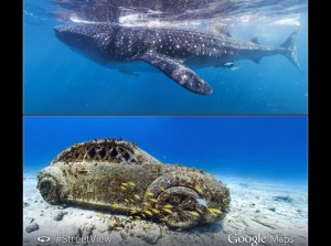
 Google on Wednesday announced the addition of new Street View scenes around Monaco to its underwater Street View imagery. The two new locations which have been added to the underwater Street View imagery collection include Cancun and Isla Mujeres. The Mountain View giant confirmed the news on its blog post, and announced that the new locations have been added in partnership with Catlin Seaview Survey.
Notably, the Catlin Seaview Survey has been creating a baseline record of the world’s coral reefs, which it says are in a state of decline, in high-resolution 360-degree panoramic vision.
Google confirmed the news via a Google+ post, saying, “New underwater #StreetView imagery in partnership with +Catlin Seaview Survey including Isla Mujeres and Cancun.”
It’s worth pointing out that Google has been working with the Catlin Seaview Survey for other projects that include gathering photos of the biological diversity of the Galapagos Islands for the search giant’s online maps.
The Catlin Seaview Survey uses special photography gear to collect high-definition, panoramic images in the waters of the archipelago, which is listed as a United Nations World Heritage Site.
Google launched the Street View underwater, offering virtual dives in coral reefs in September last year.
In December, Google updated its Google Maps service with a new feature that allowed users to build their own Street View map of a location, by using Android photo sphere or a DSLR.
Google in December explained that users could now take the help of a new feature in Views community to connect their photo spheres to create a 360 degree virtual tour of a place and share them on Google Maps. Much like the Street View, users can embed the interactive viewer on their website or create apps with it using the Google Maps API.
Source- NDTV